Home > Europe > United Kingdom > England > London > Towns > Welling
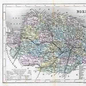
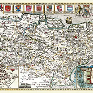
Old County Map of Norfolk 1836 by Thomas Moule

![]()
Wall Art and Photo Gifts from MapSeeker
Old County Map of Norfolk 1836 by Thomas Moule
This is a fine decorative reproduction County Map of Norfolk from the First Edition series of Thomas Moule Maps, originally Published in 1836. The well-known series of County Maps which are known as Moules feature beautiful vignette views and were first published in separate sections for each county in 1830-32, they were then published in collected form in a two-volume work: The English Counties Delineated: or a Topographical Description of England: Illustrated by a Complete Series of County Maps by Thomas Moule: London: Published by George Virtue 1836
Welcome to the Mapseeker Image library and enter an historic gateway to one of the largest on-line collections of Historic Maps, Nostalgic Views, Vista's and Panorama's from a World gone by.
Media ID 20347903
© Mapseeker Publishing Ltd
County Map County Map Of England English County Map Historic Map Moule Map Old County Map Old English County Map Old Moule Map Thomas Moule Thomas Moule Map
FEATURES IN THESE COLLECTIONS
> Arts
> Artists
> M
> Thomas Moule
> Europe
> United Kingdom
> England
> London
> Towns
> Welling
> Europe
> United Kingdom
> England
> Maps
> Europe
> United Kingdom
> England
> Norfolk
> Related Images
> Europe
> United Kingdom
> England
> Wells
> Maps and Charts
> Early Maps
> Maps and Charts
> Related Images
> MapSeeker
> Maps from the British Isles
> England and Counties PORTFOLIO
EDITORS COMMENTS
This exquisite print showcases the "Old County Map of Norfolk 1836" by Thomas Moule, a renowned cartographer of his time. Originally published in 1836 as part of Moule's First Edition series, this decorative reproduction captures the intricate details and charm of the original map. Moule's county maps are highly regarded for their captivating vignette views, which add an artistic touch to the geographical accuracy they offer. The Norfolk map is no exception, featuring stunning illustrations that bring to life the historical landmarks and natural beauty of this English county. First released as separate sections for each county between 1830 and 1832, these maps were later compiled into a two-volume work titled "The English Counties Delineated: or a Topographical Description of England". Published by George Virtue in London in 1836, this comprehensive collection solidified Moule's reputation as one of the leading cartographers of his era. As you gaze upon this historic treasure, you can immerse yourself in Norfolk's rich heritage. From its picturesque coastline to its charming towns and villages nestled amidst rolling countryside, this map offers a glimpse into Norfolk's past while serving as an elegant piece of decor for any space. Whether you're a history enthusiast or simply appreciate fine artistry, this print allows you to own a piece of Thomas Moule's legacy and proudly display it within your home or office.
MADE IN THE USA
Safe Shipping with 30 Day Money Back Guarantee
FREE PERSONALISATION*
We are proud to offer a range of customisation features including Personalised Captions, Color Filters and Picture Zoom Tools
SECURE PAYMENTS
We happily accept a wide range of payment options so you can pay for the things you need in the way that is most convenient for you
* Options may vary by product and licensing agreement. Zoomed Pictures can be adjusted in the Cart.