Home > Europe > France > Canton > Landes
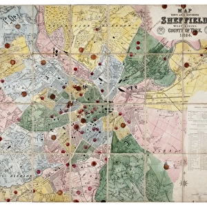
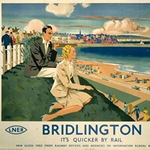
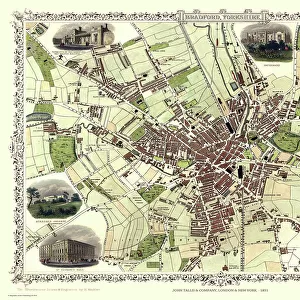
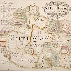
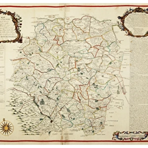
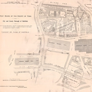
Map of the County of York, by John Tuke, land surveyor, 1787

![]()
Wall Art and Photo Gifts from Sheffield City Archives
Map of the County of York, by John Tuke, land surveyor, 1787
From an original at Sheffield Libraries: arc03407
Sheffield City Archives and Local Studies Library has an unrivalled collection of images of Sheffield, England
Media ID 19171493
© Sheffield City Council
Barnsley Doncaster Rotherham Sheffield Yorkshire Beverley Bradford East Riding Hull Leeds Ripon West Riding
FEATURES IN THESE COLLECTIONS
> Europe
> France
> Canton
> Landes
> Europe
> United Kingdom
> England
> East Riding of Yorkshire
> Related Images
> Europe
> United Kingdom
> England
> West Yorkshire
> Bradford
> Europe
> United Kingdom
> England
> West Yorkshire
> Leeds
> Europe
> United Kingdom
> England
> West Yorkshire
> Related Images
> Europe
> United Kingdom
> England
> Yorkshire
> Barnsley
> Europe
> United Kingdom
> England
> Yorkshire
> Bradford
> Europe
> United Kingdom
> England
> Yorkshire
> Doncaster
> Europe
> United Kingdom
> England
> Yorkshire
> Hull
> Europe
> United Kingdom
> England
> Yorkshire
> Leeds
> Sheffield City Archives
> Maps and Plans
> Maps of Yorkshire
EDITORS COMMENTS
Map of the County of York, by John Tuke, land surveyor, 1787 (From an original at Sheffield Libraries: arc03407) captures the rich historical tapestry and intricate details of one of England's most significant regions. This remarkable print showcases the expertise and meticulous craftsmanship of John Tuke, a renowned land surveyor from Yorkshire. Spanning across vast landscapes and encompassing iconic cities such as Leeds, Bradford, Sheffield, and York itself, this map offers a captivating glimpse into the county's past. From bustling urban centers to quaint rural villages nestled amidst rolling hillsides, every inch is meticulously illustrated with precision. As we explore further into its depths, we encounter notable landmarks like Doncaster's impressive castle ruins or Rotherham's charming market square. The map also highlights important industrial hubs such as Barnsley and Hull that played pivotal roles in shaping Yorkshire's economic growth during that era. Beyond these urban centers lie hidden gems like Ripon with its stunning cathedral or Beverley boasting its magnificent Minster - testaments to Yorkshire's architectural grandeur. Furthermore, it delineates between West Riding and East Riding while showcasing their unique characteristics. This print from Sheffield City Archives not only serves as a visual delight but also acts as a valuable historical artifact preserving our connection to the past. It allows us to appreciate how much has changed over centuries while reminding us of the enduring spirit that defines this remarkable region.
MADE IN THE USA
Safe Shipping with 30 Day Money Back Guarantee
FREE PERSONALISATION*
We are proud to offer a range of customisation features including Personalised Captions, Color Filters and Picture Zoom Tools
SECURE PAYMENTS
We happily accept a wide range of payment options so you can pay for the things you need in the way that is most convenient for you
* Options may vary by product and licensing agreement. Zoomed Pictures can be adjusted in the Cart.
![Steel Peech and Tozer Social Services, gala and sports meeting, Saturday 11th June [c. 1930s], Sports Ground, Brinsworth](/sq/716/steel-peech-tozer-social-services-14727880.jpg.webp)