Home > Science Photo Library > Aerial and Satellite
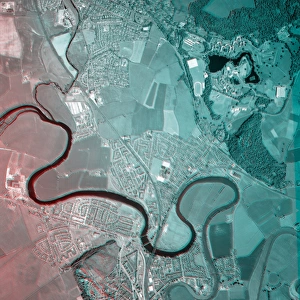
Moscow, Russia, satellite image

![]()
Wall Art and Photo Gifts from Science Photo Library
Moscow, Russia, satellite image
Moscow, Russia. Satellite image of the city of Moscow (centre) and its surrounding area in west-central Russia. North is at top. The Moskva river is seen running diagonally through the city. Forested areas are dark green, agricultural fields are lighter shades of green and brown, urban areas are grey, and water is black. Image created using NaturalVue data obtained from the Landsat 7 satellite
Science Photo Library features Science and Medical images including photos and illustrations
Media ID 1705001
© EARTH SATELLITE CORPORATION/SCIENCE PHOTO LIBRARY
Capital City Cloud Clouds Earth Observation Farm Land Field Fields Forest Forests From Space Landsat 7 Moscow Nasa Natural Colour Naturalvue River Russia Russian Satellite Satellite Image Urban Urbanisation Urbanization Vegetation Wood Land Moskva River
EDITORS COMMENTS
This print showcases the stunning cityscape of Moscow, Russia as seen from a satellite's perspective. The image captures the vastness and diversity of this European capital, with its urban areas depicted in shades of grey against a backdrop of lush green forests and agricultural fields. The iconic Moskva river cuts through the heart of the city, adding a dynamic element to the composition. Its dark waters create a striking contrast against the surrounding landscape. The natural colours captured by NaturalVue data obtained from Landsat 7 satellite provide an authentic representation of Moscow's geography. From space, one can truly appreciate the magnitude of urbanization that has taken place in this metropolis. Clouds hover above, casting shadows over both rural and urban areas, while highlighting their distinct features. This satellite image offers a unique perspective on how humans have transformed vast stretches of land into thriving cities. Beyond its aesthetic appeal, this photograph also serves as a valuable tool for geographical analysis and earth observation studies conducted by organizations like NASA. It allows researchers to study patterns in vegetation distribution, water bodies' impact on land use, and even analyze changes brought about by urban expansion. In summary, this remarkable print provides us with an awe-inspiring view of Moscow's metropolitan area from space. It encapsulates not only the beauty but also important scientific insights into our ever-changing world.
MADE IN THE USA
Safe Shipping with 30 Day Money Back Guarantee
FREE PERSONALISATION*
We are proud to offer a range of customisation features including Personalised Captions, Color Filters and Picture Zoom Tools
SECURE PAYMENTS
We happily accept a wide range of payment options so you can pay for the things you need in the way that is most convenient for you
* Options may vary by product and licensing agreement. Zoomed Pictures can be adjusted in the Cart.