Home > Animals > Mammals > Cats (Domestic) > Turkish Van
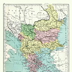
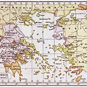
European Turkey map by Th. Duvotenay

![]()
Wall Art and Photo Gifts from Mary Evans Picture Library
European Turkey map by Th. Duvotenay
European Turkey map by Thunot Duvotenay. Historia de Turquia by Joseph Marie Jouannin (1783-1844) and Jules Van Gaver, 1840. Date: 2018
Mary Evans Picture Library makes available wonderful images created for people to enjoy over the centuries
Media ID 32246308
© Thaliastock / Mary Evans
1840 Adriatic Albania Balkans Bosnia Bosphorus Bulgaria Cartography Constantinople Domination Mapping Marmara Ottomans Romania Strait Territory Turks Wallachia Ottoman Walachia
FEATURES IN THESE COLLECTIONS
> Animals
> Mammals
> Cats (Domestic)
> Turkish Van
> Asia
> Turkey
> Related Images
> Europe
> Albania
> Related Images
> Europe
> Bosnia and Herzegovina
> Maps
> Europe
> Bulgaria
> Related Images
> Mary Evans Prints Online
> New Images July 2023
EDITORS COMMENTS
This map print, titled "European Turkey" by Th. Duvotenay, is an intriguing glimpse into the political landscape of the European continent during the 19th century. Dated back to 1840, this map was created during the Ottoman Empire's gradual decline, and it illustrates the territorial dominion of the Turks in Europe. The map covers a vast expanse of Europe, stretching from the Adriatic Sea in the west to the Black Sea in the east. The Ottoman territories are depicted in rich, bold tones, highlighting the extent of their influence in the Balkans. The map includes detailed renderings of various regions, such as Albania, Bosnia, Bulgaria, Romania, and Wallachia. One of the most striking features of this map is the clear depiction of the Straits of the Bosphorus and the Dardanelles, which connect Europe and Asia. Constantinople, the historic capital city of the Ottoman Empire, is also prominently displayed. The map's intricate detailing is a testament to the advanced cartography and engraving techniques of the time. This map is an essential historical document, as it provides valuable insights into the geopolitical situation of Europe during the 19th century. It is a reminder of the complex and dynamic nature of European history, as well as the enduring influence of the Ottoman Empire. The map is a beautiful and intriguing piece of historical art, and it continues to fascinate scholars, historians, and enthusiasts of cartography and mapping.
MADE IN THE USA
Safe Shipping with 30 Day Money Back Guarantee
FREE PERSONALISATION*
We are proud to offer a range of customisation features including Personalised Captions, Color Filters and Picture Zoom Tools
SECURE PAYMENTS
We happily accept a wide range of payment options so you can pay for the things you need in the way that is most convenient for you
* Options may vary by product and licensing agreement. Zoomed Pictures can be adjusted in the Cart.