Home > Europe > United Kingdom > Wales > Pembrokeshire > Haverfordwest
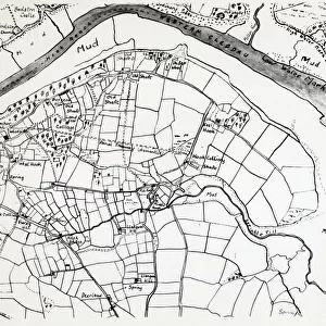
Colliery map of Hook, Pembrokeshire, South Wales

![]()
Wall Art and Photo Gifts from Mary Evans Picture Library
Colliery map of Hook, Pembrokeshire, South Wales
A colliery map (by Thomas Lewis) of the village of Hook, described here as West Hook in the parish of Langwn (Llangwm), showing fields, trees and mining locations. Hook is on the Western Cleddau near Haverfordwest, Pembrokeshire, South Wales
Mary Evans Picture Library makes available wonderful images created for people to enjoy over the centuries
Media ID 4474289
© Mary Evans Picture Library 2015 - https://copyrighthub.org/s0/hub1/creation/maryevans/MaryEvansPictureID/10428809
1770s 1776 Cleddau Coal Mine Colliery Estuary Fields Haverfordwest Hook Lewis Llangwm Maps Mine Mining Parish Pembrokeshire
FEATURES IN THESE COLLECTIONS
> Animals
> Mammals
> Muridae
> Western Mouse
> Arts
> Landscape paintings
> Waterfall and river artworks
> River artworks
> Europe
> United Kingdom
> Wales
> Maps
> Europe
> United Kingdom
> Wales
> Pembrokeshire
> Haverfordwest
> Europe
> United Kingdom
> Wales
> Pembrokeshire
> Related Images
> Europe
> United Kingdom
> Wales
> Posters
> Europe
> United Kingdom
> Wales
> Related Images
> Europe
> United Kingdom
> Wales
> Rivers
> Maps and Charts
> Early Maps
> Maps and Charts
> Related Images
EDITORS COMMENTS
This print showcases an 18th-century colliery map of the historic Welsh village of West Hook, located in the picturesque parish of Llangwm, Pembrokeshire, South Wales. Drawn by Thomas Lewis in the year 1776, this map offers a fascinating glimpse into the past, revealing the intricate details of the village's landscape during the era of coal mining. West Hook, now known simply as Hook, is nestled on the western banks of the River Cleddau, near Haverfordwest. The map meticulously illustrates the village's fields, trees, and mining locations, providing a unique insight into the rural community's agricultural and industrial past. Thomas Lewis's map is an essential historical document, offering a detailed record of the village's topography during the 1770s. The map's intricate details reveal the extent of the coal mining industry in the region, with various mining locations marked throughout the map. The presence of coal mines in the area would have significantly impacted the local economy, contributing to the growth and development of the village. The map's antique charm transports us back in time, allowing us to imagine the daily life of the villagers of West Hook during the late 18th century. The map's intricate details, from the winding river to the individual trees, offer a captivating window into the past, making it an invaluable resource for anyone interested in the history of Pembrokeshire and South Wales.
MADE IN THE USA
Safe Shipping with 30 Day Money Back Guarantee
FREE PERSONALISATION*
We are proud to offer a range of customisation features including Personalised Captions, Color Filters and Picture Zoom Tools
SECURE PAYMENTS
We happily accept a wide range of payment options so you can pay for the things you need in the way that is most convenient for you
* Options may vary by product and licensing agreement. Zoomed Pictures can be adjusted in the Cart.