Home > Arts > Artists > H > Jodocus Hondius
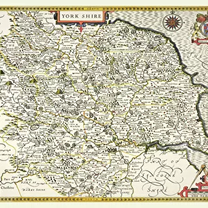
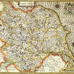
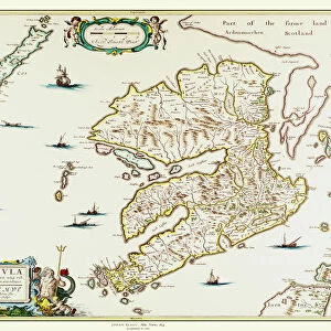
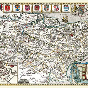
Old County Map of the East Riding of Yorkshire 1648 by Johan Blaeu from the Atlas Novus

![]()
Wall Art and Photo Gifts from MapSeeker
Old County Map of the East Riding of Yorkshire 1648 by Johan Blaeu from the Atlas Novus
This detailed and most attractive reproduction map of the East Riding of Yorkshire has been carefully art worked from a scan of an antique original. The famous firm of Dutch cartographers and publishers was established in the late 16th century by Willem Janszoon Blaeu in Amsterdam. Blaeu was a maker of globes and scientific instruments and purchased some of his early map plates from Jodocus Hondius. From this small beginning was to emerge one of the largest and most prolific map publishing houses of the seventeenth century
Welcome to the Mapseeker Image library and enter an historic gateway to one of the largest on-line collections of Historic Maps, Nostalgic Views, Vista's and Panorama's from a World gone by.
Media ID 20347860
Blaeu Blaeu Family Blaue Map County Map County Map Of England English County Map Historic Map Johan Blaeu Johan Blaeu Map Old Blaue Map Old County Map Old English County Map
FEATURES IN THESE COLLECTIONS
> Arts
> Artists
> B
> Willem Blaeu
> Arts
> Artists
> H
> Jodocus Hondius
> Arts
> Photorealistic artworks
> Detailed art pieces
> Masterful detailing in art
> Europe
> United Kingdom
> England
> East Riding of Yorkshire
> Related Images
> Europe
> United Kingdom
> England
> Maps
> Europe
> United Kingdom
> England
> Yorkshire
> Related Images
> Maps and Charts
> Early Maps
> Maps and Charts
> Related Images
> Maps and Charts
> Willem Janszoon Blaeu
> MapSeeker
> Maps from the British Isles
> England and Counties PORTFOLIO
EDITORS COMMENTS
This beautifully crafted reproduction of the "Old County Map of the East Riding of Yorkshire 1648" by Johan Blaeu takes us back in time to a period when cartography was both an art and a science. Carefully art worked from an antique original, this detailed map showcases the expertise and precision that made Blaeu's maps highly sought after during the seventeenth century. The renowned Dutch firm established by Willem Janszoon Blaeu in Amsterdam became one of the largest and most prolific map publishing houses of its time. Starting as a maker of globes and scientific instruments, Blaeu expanded his repertoire by acquiring map plates from Jodocus Hondius, setting him on a path towards becoming one of history's most esteemed cartographers. This historic map provides us with a fascinating glimpse into the past, offering insights into how Yorkshire's East Riding appeared over three centuries ago. Its intricate details capture not only geographical features but also historical landmarks that have shaped this region throughout time. Whether you are an avid collector or simply appreciate the beauty and significance of old maps, this reproduction is sure to captivate your imagination. It serves as a testament to Johan Blaeu's legacy as well as our enduring fascination with preserving historical artifacts for generations to come.
MADE IN THE USA
Safe Shipping with 30 Day Money Back Guarantee
FREE PERSONALISATION*
We are proud to offer a range of customisation features including Personalised Captions, Color Filters and Picture Zoom Tools
SECURE PAYMENTS
We happily accept a wide range of payment options so you can pay for the things you need in the way that is most convenient for you
* Options may vary by product and licensing agreement. Zoomed Pictures can be adjusted in the Cart.