Home > Animals > Fishes > S > Sea Bass
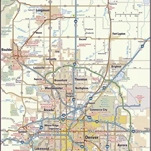
MA Essex Gloucester Vector Road Map

![]()
Wall Art and Photo Gifts from Fine Art Storehouse
MA Essex Gloucester Vector Road Map
MA Essex Gloucester Vector Road Map. All source data is in the public domain. U.S. Census Bureau Census Tiger. Used Layers: areawater, linearwater, roads, rails, cousub, pointlm, uac10
Unleash your creativity and transform your space into a visual masterpiece!
Frank Ramspott
Media ID 20689709
© Frank Ramspott, all rights reserved
Atlantic Ocean City Map Computer Graphic County Digital Composite District Essex Geographical Border Harbor Magnolia Massachusetts Road Map Text Vector Annisquam Digitally Generated Image Gloucester Rockport Rocky Neck
FEATURES IN THESE COLLECTIONS
> Animals
> Fishes
> S
> Sea Bass
> Animals
> Mammals
> Cats (Wild)
> Tiger
> Animals
> Mammals
> Muridae
> Water Mouse
> Arts
> Artists
> O
> Oceanic Oceanic
> Arts
> Contemporary art
> Digital artwork
> Street art
> Arts
> Landscape paintings
> Waterfall and river artworks
> River artworks
> Arts
> Portraits
> Pop art gallery
> Street art portraits
> Arts
> Street art graffiti
> Digital art
> Digital paintings
> Europe
> United Kingdom
> England
> Essex
> Related Images
> Fine Art Storehouse
> Map
> Reference Maps
> Maps and Charts
> Related Images
EDITORS COMMENTS
This vibrant and detailed print captures the essence of MA Essex Gloucester like never before. A masterpiece in cartography, this digitally generated image showcases the intricate road network that weaves through this picturesque county. Designed with precision and utilizing data from the U. S. Census Bureau Census Tiger, every street, town, and geographical feature is accurately represented. The color image brings to life the physical geography of MA Essex Gloucester, highlighting its stunning coastline along the Atlantic Ocean. From Magnolia to Rockport, each city and town is clearly labeled, allowing viewers to navigate their way through this charming region effortlessly. Notably absent of people but rich in visual appeal, this computer graphic seamlessly combines various layers such as roads, rails, rivers, lakes, and even points of interest like Sunset Hill and Bass Rocks. The result is a visually striking digital composite that showcases both natural beauty and man-made infrastructure. With its impeccable attention to detail and clear presentation of geographical borders, this print serves as an invaluable tool for locals or visitors looking to explore MA Essex Gloucester's hidden gems. Whether you're planning a scenic drive or simply admiring the artistry behind cartography itself - Frank Ramspott's creation offers endless fascination for those who appreciate fine design intertwined with practicality.
MADE IN THE USA
Safe Shipping with 30 Day Money Back Guarantee
FREE PERSONALISATION*
We are proud to offer a range of customisation features including Personalised Captions, Color Filters and Picture Zoom Tools
SECURE PAYMENTS
We happily accept a wide range of payment options so you can pay for the things you need in the way that is most convenient for you
* Options may vary by product and licensing agreement. Zoomed Pictures can be adjusted in the Cart.