Home > Arts > Artists > M > Garrick Mallery
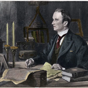
Map of Little Big Horn Battle Field (colour litho)
")
![]()
Wall Art and Photo Gifts from Fine Art Finder
Map of Little Big Horn Battle Field (colour litho)
980722 Map of Little Big Horn Battle Field (colour litho) by American School, (19th century) (after); Private Collection; (add.info.: Map of Little Big Horn Battle Field. Illustration for an article on Picture-writing of the American Indians by Garrick Mallery. From the Tenth Annual Report of the Bureau of Ethnology to the Secretary of the Smithsonian Institution, 1888-89 by J W Powell, Director (Washington, Government Printing Office, 1893).); Look and Learn / Elgar Collection
Media ID 22745834
© Look and Learn / Elgar Collection / Bridgeman Images
1876 American Indian American Indians American Native Indians Anthropology Battles Custers Last Stand Diagram Diagrams Engravings Ethnographic Ethnology Great Sioux War Indigenous Little Bighorn North American Northern Cheyenne Peoples Battle Field Battle Of Little Big Horn Lakota Sioux Little Big Horn
FEATURES IN THESE COLLECTIONS
> Animals
> Mammals
> Muridae
> Western Mouse
> Arts
> Artists
> I
> Indian School Indian School
> Arts
> Artists
> M
> Garrick Mallery
> Asia
> India
> Related Images
> Fine Art Finder
> Artists
> Sydney Prior (after) Hall
> Fine Art Finder
> Schools
> American School
> Fine Art Finder
> Temp Classification
> Historic
> Battles
> Battle at Little Bighorn
> Historic
> Battles
> Related Images
> Maps and Charts
> Early Maps
> Maps and Charts
> India
EDITORS COMMENTS
This vibrant and detailed lithograph captures the essence of the historic Battle of Little Big Horn, providing a visual representation of this significant event in American history. The map, created by an anonymous 19th-century American artist, showcases the battlefield where General George Custer and his troops clashed with Native American tribes. The illustration was originally featured in an article on Picture-writing of the American Indians by Garrick Mallery, published in the Tenth Annual Report of the Bureau of Ethnology to the Secretary of the Smithsonian Institution in 1888-89. It offers valuable insights into indigenous communication methods and cultural practices during that time. The map depicts not only geographical features but also highlights key elements such as battle scenes, tribal territories, and important landmarks. It serves as a fascinating glimpse into both military strategy and ethnographic study. Through this print, viewers are transported back to 1876 when tensions between Native Americans and settlers were at their peak. The clash between Northern Cheyenne warriors led by Sitting Bull and Lakota Sioux fighters against Custer's Seventh Cavalry Regiment resulted in a decisive victory for the Native Americans. This artwork allows us to delve deeper into America's past while shedding light on crucial aspects such as anthropology, history, and intercultural dynamics. Its vivid colors bring life to an otherwise distant historical event while reminding us of our nation's complex heritage.
MADE IN THE USA
Safe Shipping with 30 Day Money Back Guarantee
FREE PERSONALISATION*
We are proud to offer a range of customisation features including Personalised Captions, Color Filters and Picture Zoom Tools
SECURE PAYMENTS
We happily accept a wide range of payment options so you can pay for the things you need in the way that is most convenient for you
* Options may vary by product and licensing agreement. Zoomed Pictures can be adjusted in the Cart.